Hike Statistics
Date(s): 5/28/2006
Route: High Point Trail from the Picnic Area
Distance: 0.9 miles (Other longer hikes are in the area)
Elevation: 3213 ft.
Elevation Change: 56 ft. (Less than what I ascend to get into my five flight walk-up)
Time: About 10 minutes
Download Waypoints
Good ole PA! Land of my birth. And the next highpoint to conquer in my quest to do 49 (Alaska is just too much). Pennsylvania is a long state. Ask anyone who has driven across the top via route 80 going from New York to Chicago. It goes on forever (about eight hours). Actually, only the 32nd state in size, it feels bigger because it’s divided by the Allegheny Mountains slicing across the center from southwest to northeast. Like poles on a magnet, Pittsburgh and Philadelphia are opposites sitting on each end of the state, separated by these Appalachian peaks.
Back in the day, crossing these mountains was no small task. It took a gazillion engineers something like three hundred years to create the Horseshoe Curve to connect the East Coast to the rest of the country via the railroad. This is a story for another day. Today’s tale is how I convinced my girlfriend and parents to take a drive PA’s highest point, Mount Davis.
Although PA has cities at the ends, the rest is farms in the valleys surrounded by forest-covered ridgelines. It’s all trees. This makes for lovely autumns, but sometimes monotonous summer drives in a sea of green.
 |
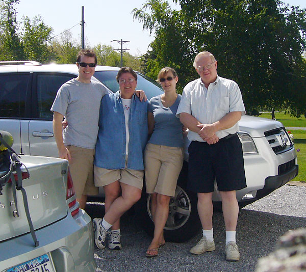
Ildi learned a valuable lesson about my father, air-conditioning, and being prepared. My parent’s new Honda Pilot was actually a roomy dream. The reason so many people have SUVs is that they are really, really comfortable and nice to drive. |
 |
Mount Davis is in southwest central PA, not too far from Somerset. It’s about 90 miles from either Altoona or Pittsburgh. If you come from the east, take 219 to Business 219 in Meyersdale. There look for signs for Mt. Davis Road or SR (State Route) 2004. This pic shows what you’ll see if you are not seeing trees. It also shows how PA has decent signage for its back roads. |
 |
The “mountain” is actually just a hill on a plateau, no where near as dramatic or worthy for hiking as Nittany Mountain in State College or the Pine Creek Gorge in Tioga County. Still it is the highest point. Thus we go. |
 |
Before the ardous climb, we bolstered our strength with sandwiches the girls had packed. Mine was lebanon bologna. Even though it was a holiday weekend, we had the picnic area mostly to ourselves. There are restrooms in case you were wondering. Composting restrooms, Ildi notes. |
 |
Spring had reached PA and the buttercups were in bloom. |
 |
I don’t know the name of this flower, so I’m going to christen it the Boring Lily. I promise to limit the flower shots during the next hike. Note, the tops of these flowers were about the size of nickels. They are not daisies. |
 |
The highpoint is marked on the road, but in my opinion, if you stopped there it would not count. |
 |
Apparantly some locals agree and took some shots at the sign with a shotgun. In seriousness, I’ve seen so many signs shot with all sorts of weapons when I am in the country. I never did this. What the hell would compel someone to shoot a sign? I hope in some weird way it causes sterilization. |
 |
The trail does not start from the road, but rather from the back right corner of the picnic area… |
 |
…And then it is over. My parent’s drove the car around and we almost tied. On the sandstone behind us is the geological survey marker, indicating the true highpoint. |
 |
Here’s the shot for the records. Mount Davis was not recognized as the highpoint of the state until 1921. Until then, it was just a bump on the much larger Negro Mountian. Legend has it this mountian was named after a black man who was a hero during the French and Indian War. Local knowledge states that Negro Mountain once had a much less politically correct name that wraps the whole thing in unpleasantness. I’ll admit PA is a bit hickish in the middle, but we did wear blue back in the Civil War (or the War of Northern Aggression, as NC-native Erik calls it). |
 |
The site has a fire tower. My dad and I climbed it. I met this nice couple, who are also fellow highpointers. She was on #2 and this was his first. Both Ildi and my parents now are done with number one. Once you start counting, you are hooked. |
 |
The only view from the top was my family below siiting beside the point. That woman with brass hair is not with our group. |
 |
“During the upheaval called the Appalachian Revolution.” Awesome. |
Even though the view was just so-so, the weather and sandwiches were both awesome. Plus, this was my first highpoint I got to share with my parents and Ildi. This is my seventh highpoint. Hopefully, I can include more loved ones, more state learning, more locals, and despite what they all want, more hiking.
In the next post, some Pennsylvania attractions near Mt. Davis: the rapids at Ohiopyle and Frank Lloyd Wright’s Falling Water.
Links:
– AmericasRoof.com Mt. Davis report
– Backpacker.com Mt. Davis
– Dept. of Conservation and Natural Resource Mt. Davis site