Hike Statistics
Date(s): 10/6/2001
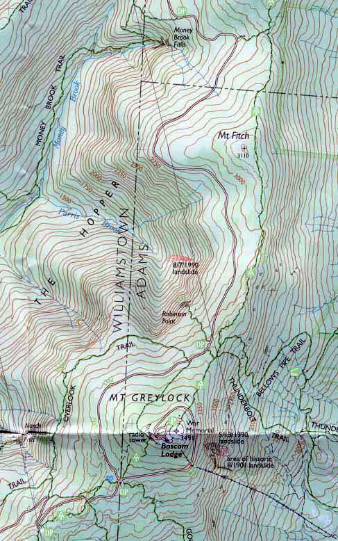
Route:From the AT parking lot in North Adams, MA, by the Mt. Williams Reservoir on Pattison Road, following the AT to the peak, backtracking and descending to Thunderbolt Trail to parking lot in Adams on Thiel Road.
Distance: 7.1 miles
Elevation Change: 2491 ft. from parking lot at 1000 ft. to peak at 3491 ft.
From the email that spawned this hike:
Date: Mon, 10 Sep 2001
This is the latest update for our Fall camping trip. We are definitely on for the weekend of October 5, 6, & 7. Because different people in the group have different amounts of equipment, I was thinking we could car camp, but do an 11 mile throught hike on the AT over Mt. Greylock on Saturday. This means we get exercise, see lots of fall colors, but still can bring tons of beer. Erik and I did a similar trip in the Catskills this weekend and it worked out great.
 |
Jerry and I talking about camping. |
 |
We drank tequila and Squirt until it seemed like a good idea. |
 |
I bought a tent. |
 |
Matt made super gorp. It's Peanuts, M&M's, and Lucky Charms |
 |
Proud to be American. |
 |
Notice the chili on the grill for the dogs. Erik is holding tequila, |
 |
You can't tell, but it is raining. Really, really hard. |
 |
Peak #1 above North Adams. |
 |
The pictures do not begin to capture the colors. |
 |
Near the top. |
 |
This is the view from the top of the ridgeline we hiked. I put in arrows identifying the peaks. |
 |
Turns out there is a road to the top. We are dumb asses. |
 |
Erik taking a picure of me taking a picture of him taking a picture of me. We are through the looking glass, people! |
 |
The Thunderbolt Trail. Beautiful…but deadly. |
 |
Real sleet and snow. |
 |
The lake before we left. |
Links:
Trail Distances
Gorp Guide to Greylock