 |
| Guadalupe Peak / El Paso Vacation |
Hike Statistics
Date(s): 4/1/2007
Hikers: Dan, Ben, Erik, and me
Route: Guadalupe Peak Trail from Pine Spring Campground
Distance: 8.2 miles round trip
Elevation Change: 2927 ft. from parking lot to peak at 8749 ft.
Time: Up- 3-1/2 hours, Down – 1-1/2 hours
Guadalupe Peak is in the middle of nowhere, sort of. It's nicely between El Paso and Carlsbad Caverns, NM, but it is the only thing between them other than antelope. Everything really is bigger in Texas, and you see it as soon as you hit the Dallas airport. It's huge and even the restaurant tables are about ten feet further apart from one another than any town I've ever been in. Two hours later on another airplane and you are still in Texas. One hiker I met said, "The sun has ris', the sun has set, and I still ain't left Texas yet."
We hit the Wal-mart Super center for BBQ beef, beer, and other supplies in El Paso and then drove two hours to the Pine Springs Campground in Guadalupe Mountains National Park. Like most national parks, the facilities were excellent, clean bathrooms, no trash, and good signage. Fires are forbidden and a few minutes in the wind and dry brush explain why. The first night was cold, but that also meant the days weren't so blazing. I recommend hiking the peak in the Spring. Guadalupe is famous for high winds, but we got very lucky and the air was mostly still. The desert is a fantastic place. Sunglasses and a hat are a must. Because the air is so dry, the temperatures can vary 30 degrees from the sun to the shade.
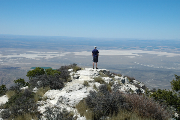
After the hike we sat around in shorts and t-shirts while the beers in the shade were cold to the touch (and drink). The trail is well-maintained and only slightly rocky. Good views are seen all the way up, but then the panorama at the top is incredible. It outclassed any other view I've yet seen. The dry air and surrounding level West Texas plateau allow you to see for hundreds of miles. We could see salt flats and gigantic green circles created by spinning irrigation. About ten degrees left of north way off in the distance was some snow covered peak that I need to look up.
Everyone did excellent on the hike, mostly due to Super Gorp and pb&js. The only wounds were some minor stiffness, one blister on my toe treated trailside, and some spots of sunburn where we missed applying. A big thanks to my aunt-in-law-to-be Dora for the hiking map and this geologic info:
Sean climbed the face of an ancient Permian reef. The way the rocks have been faulted up and then subsequently eroded is really neat because it preserved the topography of the ancient Permian seafloor. As he drove north from Van Horn he was on the deep ocean floor and then when he saw the escarpment of El Capitan – he was looking up the reef face. His hike to the top of Gaudalupe Peak was within some of the fossiliferous reef section. If he went to Carlsbad Caverns then he was within the reef proper. Geologists from all over the world travel to Gaudalupe Mountains to study this ancient reef complex to get a glimpse of how to model reefs in the subsurface.
You can view the pics in Picasa with the link above. All the pics are by Ben and Erik, which you can see near the end where they captured each other shooting each other simultaneously in their matching orange shirts.