Hike Statistics
Date(s): 5/9/2006
Route: Humphreys Trail from Snowbowl Parking Lot
Distance: 8.25 miles round trip
Elevation Change: 3272 ft. from parking lot to peak at 12,633 ft.
Time: Up- 4 hours, Down – 2-1/2 hours
In my last entry, I told you about Matt’s and my grueling hike out of the Grand Canyon and our struggle to push the gas pedal with exausted legs as we drove an hour to Flagstaff. Well, once we got there, hit the hot tub in the Hampton Inn, ate a steak dinner at Busters, and slept for twelve hours, we were ready to tackle Humphreys Peak, the tallest mountain in Arizona. My goal is to reach the highpoint of 49 states (McKinley in Alaska is just too much) and I wanted to get my first West Coast mountain under my belt on this trip. Somehow (with whiskey) I talked Matt into it.
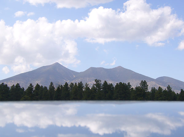
Today’s pic of the day is the mountain. The “lake” is actually the roof of Car 19.
 |
When I planned the trip, I printed out careful directions so we could find the mountain from Flagstaff. It turns out this is not necessary. Humphreys is visible from much of northern Arizona and it looms over all of Flagstaff. We could see it from our hotel there on the right. This caused Matt to repeatedly say, “Sean! You are f%$#ing crazy!” |
 |
One note on Flagstaff–not a lot going on. This wreck outside our window was the most excitement they had this year. In nearby Winslow, Arizona, the most popular thing to do is stand on a corner and hit on women in Fords. Like The Dude, I prefer no Eagles. |
 |
Humphreys is way up there compared to the East Coast peaks and there was still a decent amount of packed snow in the tree on the approach. In this shot you can see red Grand Canyon dust on Matt’s boot against the snow in the morning light. Neither one of us wanted to die yet, but we both had already gotten altitude headaches during the drive up to the parking lot at 9300 ft. |
 |
The hike is a non-technical (no ropes) climb over a relatively smooth and maintained path. At the treeline there was decent view of the slopes on the adjacent Agassiz Peak. The top of that one is reachable by ski-lift, but that would be a sensible way to get a view. |
 |
The “saddle” is reached right when you break the treeline. That is where the wind begins to kick the shit out of you. The air gets really thin at that elevation. I had read about it, but never experience it. I was huffing and puffing every 40 paces and had to rest after each short advance. For future hikes, I’m going to try and spend at least one day and night at the base. |
 |
Unfortunately there was no USGS medallion at the top for me to photograph for my highpoints quest. There was a ratty registration notebook in an ammo box. I think the park service throws it out once a year. |
 |
Here are the triumphant super hikers, in coats in Arizona in May. If you look close at Matt, you can see his smile is a bit forced. That’s because he is suffering the early symptoms of altitude sickness which are dizziness, nausea, and irritability. Luckily, the surefire cure is to walk down and he took off down the hill after this shot and didn’t die. |
 |
Humphreys sits alone on the arid Colorado Plateau and has a wonderful 360 degree view. That is except when Matt and I visit. Then it rains. Mountains create their own weather, especially when I hike them. We never actually got rained upon, but I did get some snowflakes flying up into my nose, riding the thermals up the side of the mountain. |
 |
Because of the diaspora, ‘Burghers are everywhere (except in Pittsburgh anymore apparantly) and we met this guy at the peak. He carries a terrible towel to the tops of mountains. I wish I had thought of that. |
 |
One long hike, a bottle of Makers Mark, and a night’s sleep later, we visited Meteor Crater National Park, where blessedly hiking is prohibtited. The architect put this hole in the courtyard wall to frame Humphreys, the only detail in the barren desert skyline. |
 |
Distances are weird out there. The crate looks to be a hundred yards across, but it is actual a mile. The Grand Canyon has the same optical illusion. I’m sure this trick of the eye killed many wagon trains long ago. Since hiking in the crater is not allowed, this picture is actually in front of a back drop. In hindsight, there should be Phantom Ranch and Humphreys Peak backdrops downloadable on the Internet. Then, Matt and I might still have some cartilege in our knees. |
 |
This picture is showing the correct way to put moleskin on a blister. Cover it first with nonstick gauze and then cut a hole in a piece of moleskin so that the hole is just slightly larger than the blister. Tape can help the whole thing stay put. NEVER PUT MOLESKIN DIRECTLY ON THE BLISTER. NEVER. NEVER. Doing that can cause even experienced hikers who think they know it all named Sean to end up with a severely painful blister by the time they reach the top of the canyon.
Be thankful I did not take a picture of my bloody toenails. |
Three days of hiking was great and certainly put me in touch with my limits, but we really needed a change of pace, so we hightailed it to Vegas for the exact opposite of nature. More on that in the next post.
Links:
Humpheys Peak Wiki
America’s Roof – Humphreys Peak
Ten Easy Steps to Happy Hiking Feet